Brief description: ZK-351 satellite navigation receiver is a GPS L1/L2, BDS B1/B2 dual system four-band high dynamic solution engine, up to centimeter-level positioning accuracy, support GPS/BDS single system independent positioning and GPS+BDS multi-system joint positioning, hardware size, interface, data command and imported board compatible.
The dual-star solution engine that is better than the imported board truly realizes the dual-star calculation of GPS+BDS, and adapts to a harsher and longer-distance positioning environment.
【Product Technical Characteristics】
1. The dual-star solution engine is better than that of the imported board, and the dual-star solution of GPS+BDS is truly realized, and it adapts to a harsher and longer-distance positioning environment;
2. Support GPS/BDS single system independent positioning and GPS+BDS multi-system joint positioning;
3. It is compatible with the physical size, electrical interface and command message of the imported board, and can completely replace the imported board;
4. Fast RTK, which can be installed in the measurement GNSS receiver or handheld GIS collector;
5. It can directly output PJK plane coordinates, which is easy to integrate various systems and mechanical control;
6. Support short, medium and long baselines, and the RTK operating distance can be up to 50Km;
7. Support customized services, which can meet the special needs of different industry applications;
8. 100M memory data storage, which can automatically record the original data;
9. Small size, light weight and low power consumption.
【Product Composition】
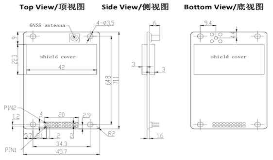
The schematic diagram of the main engine size is shown in Figure 1:
 【Main Technical Indicators】
SS Signal: |
120 channels. GPS L1C/A, L1P, L2P (can track 14 GPS satellites at the same time). BDS B1I, B2I (can track 14 BDS satellites at the same time). | Positioning time: |
Cold start: < 60s. Warm start: < 45s. Hot start (with RTC): <15s. |
| Signal Recapture: |
L1 or B1: Fast: < 1.5s; Normal: < 3s. | Pseudorange accuracy: | GPS: L1=10cm/L2=10cm; BDS:B1=10cm/B2=10cm。 |
Carrier Phase Accuracy: | GPS:L1=1.0mm/L2=1.0mm; BDS:B1=1.0mm/B2=1.0mm。 |
Standard single point Positioning accuracy: | Frequency:H≤3m, V≤5m (1σ, PDOP≤4); Dual-band:H≤1.5m, V≤3m (1σ, PDOP≤4) |
Timing accuracy: | 20ns | Data Rate: | Measurement & Positioning: 5 Hz (Max: 20 Hz) |
Static Differential Accuracy (supported by Compass Solution software): | H: ±(2.5 +1×10⁻⁶×D)mm; V: ±(5 + 1×10⁻⁶×D)mm。 | RTK Performance: |
RTK initialization time (baseline length less than 10 km): <10 seconds. Initialization confidence: > 99.9%.
|
Dynamic Differential Accuracy: | H:±(10 +1×10⁻⁶×D)mm; V:±(20 + 1×10⁻⁶×D)mm。 | Data Output Format: | NMEA-0183:GPGGA, GPGGARTK, GPGSV, GPGLL, GPGSA,GPGST, GPHDT, GPRMC, GPVTG, GPZDA etc.。 CMR(GPS):CMROBS, CMRREF。 RTCM2.X:RTCM1, RTCM3,RTCM1819,RTCM59,RTCM31。 RTCM3.0:1004,1005, 1006,1008, 1012, 1104, 1033。 RTCM3.2 MSM4:1074, 1084, 1124。 |
Electrical Characteristics: |
Data storage: 100MB (included with the board). Supply voltage: +3.3V ~ +5V±5%VDC. Power consumption (antenna not connected): 1.35W. |
Environmental Requirements: |
Operating temperature: -40°C — +80°C. Storage temperature: -55°C — +95°C. | Antenna interface: |
Antenna connector: MCX female, 50Ω. Antenna supply voltage: +3.3V ~ +5V ±5%VDC @ 0-100mA. |
Hardware Interface: |
20-pin male. Pin spacing 2mm. | Physical Parameters: |
Dimensions (including connectors): 71.1mm× 45.7mm×10.6mm (see Figure 1). Weight: 25g. |