In the previous section, when introducing the ground-based differential positioning system, it was mentioned that the differential system consists of three parts: the base station, the mobile station, and the communication link. The transmission distance of the communication link is an important factor in determining differential positioning. If a wireless communication data link is used as a communication link, the effective range of differential positioning is generally within a range of tens of kilometers. Is there a communication link that can broadcast differential correction information within a range of thousands of kilometers, ensuring that mobile stations within a range of thousands of kilometers can receive the differential correction information, thereby obtaining high-precision differential positioning results?
Yes, this is satellite-based differential correction. Satellite-based differential correction uses geosynchronous satellites as communication links to broadcast differential correction information within a coverage area of several thousand kilometers.
Fundamental
Comparison with foundation differential
The world's major satellite-based differential systems
How does a GNSS receiver receive differential information?
Satellite-based differential positioning accuracy
Fundamental
The satellite-based differential system is mainly composed of ground reference stations, ground communication networks, master control stations, geosynchronous satellites, etc. all over the world. The operating principle and process of the entire system are divided into the following parts:
Ground reference stations receive signals from GNSS satellites and accurately measure the time delay and error of satellite signals. Since ground reference stations are located all over the world, they can receive all satellites in the entire GNSS constellation at the same time and accurately measure the delay and error information of all satellites.
The delay and error information measured by the ground reference station is collected to the master control station through the ground communication network (mainly ground optical fiber and telecommunication network);
The master control station processes the received data to identify satellite orbit deviations, clock deviations, and delays in the signal propagation path (especially the ionosphere and troposphere), and generates correction information based on this: including each satellite's ephemeris error, clock error, and an estimate of the ionospheric delay for a specific area;
After the master control station calculates the correction information, it injects the correction information into the geosynchronous satellite through the satellite uplink transmission link.
Geosynchronous satellites broadcast correction information in a specified frame format.
User GNSS receivers receive correction information from geosynchronous satellites and correct satellite orbit errors, clock biases, and signal propagation errors when solving positioning solutions.
Comparison with foundation differential
Compare Projects
Satellite-Based Differential Satellite System (SBAS)
Ground Based Differential Scaling (GBAS)
|
|
|
Coverage | Covering a large area, such as an entire continent or intercontinental | The coverage area is relatively small, usually limited to an area of a few kilometers to tens of kilometers. |
Service consistency | All users within the satellite signal coverage area can receive the same correction information | Dedicated system, users receive correction information requested by the nearest user |
Dedicated | It is not exclusive to any single user or organization, and any user in the coverage area can receive it for free. | Usually a differential system built by the user to serve a specific business |
Communication link | Transmit differential correction information via satellite as communication link | Generally, differential correction information is transmitted via ground communication networks or wireless communication links. |
The cost | It can work with a GNSS receiver, and SBAS is free for users | Need to invest in ground equipment or pay service fees |
positioning accuracy | The positioning accuracy is generally close to 1m, which is relatively low. | The positioning accuracy can be less than a meter, which is relatively high |
In general: SBAS is more suitable for situations where wide coverage is required and the accuracy requirements are not extremely high, while GBAS is more suitable for application scenarios that require extremely high accuracy and have a relatively limited scope of use.
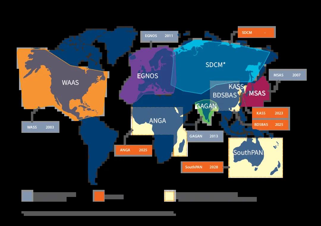
The world's major satellite-based differential systems
The main satellite-based differential systems in the world are:
The United States' WAAS (Wide Area Augmentation System): has about 3 geosynchronous satellites, covering North America and its surrounding areas.
Europe's EGNOS (European Geostationary Navigation Overlay Service): has 3 satellites and mainly serves Europe.
Japan's QZSS (MTSAT Satellite Augmentation System): serves Japan and its surrounding areas.
India's GAGAN (GPS Aided Geo Augmented Navigation): aims to improve the accuracy and integrity of aviation navigation over India.
China's Beidou Navigation Satellite System (BDS): currently has 5 satellites, providing regional services for the Asia-Pacific region;
When we observe the output information interface of the GNSS receiver, when the satellite identifier displayed on the software interface is SBAS, the satellite is a geosynchronous orbit satellite with satellite-based differential.
How does a GNSS receiver receive differential information?
In the ground-based differential system, both the base station and the mobile station are equipped with communication links, and the transmission of differential correction data is achieved through wireless communication links. The communication link and the GNSS receiver are two completely independent components. The GNSS receiver must rely on the wireless communication link to obtain differential correction information.
So, in satellite-based differential tracking, users only have GNSS receivers but no wireless communication links. How can they obtain the differential correction information broadcast by satellites?
This issue was taken into consideration when the satellite-based differential system was established.
The radio frequency points emitted by geosynchronous satellites of satellite-based differential are usually the same as the L1 and L2 frequency bands used by the GPS system. Existing GNSS receivers can normally receive satellite-based differential information.
The US WAAS system uses the same L1 and L2 frequencies as GPS to transmit signals. These frequencies are: L1 frequency: 1575.42 MHz, L2 frequency: 1227.60 MHz;
The European EGNOS system uses two frequency bands to broadcast differential correction information:
L1 frequency: 1575.42 MHz, the same as the L1 frequency of GPS, used to provide basic positioning services and correction information.
E5 frequency: 1191.795 MHz, the same as Galileo's E5 frequency, used to provide higher accuracy and integrity services.
Japan's QZSS system uses four frequency bands to broadcast differential correction information:
L1 frequency: 1575.42 MHz, the same as the L1 frequency of GPS, for compatibility with GPS systems.
L2 frequency: 1227.60 MHz, the same as the L2 frequency of GPS, used to provide high-precision services.
L5 frequency: 1176.45 MHz, the same as the L5 frequency of GPS, designed for civil aviation and higher performance services.
L6 frequency: 1278.75 MHz, a frequency unique to QZSS, used to transmit enhanced information and additional services.
China's BeiDou navigation and positioning system uses the B1C band (the same frequency band as GPS L1, 1575.42 MHz) and B2a band (the same frequency band as GPS L5 and Galileo E5a) of geosynchronous satellites (GEO) to broadcast regional differential correction information, providing users around China with correction information on BeiDou satellite's orbit error, clock error and ionospheric error.
Satellite-based differential positioning accuracy
When the GNSS receiver is positioning, it uses the broadcast ephemeris and time information of the GNSS satellite, plus the satellite-based differential information broadcast by the synchronous satellite (GEO) satellite to complete the differential positioning. After using satellite-based differential, the positioning accuracy of the GNSS receiver can be close to 1m, about 1.5m~3m.